Google, Partners Launch First FireSat Satellite, Using AI to Detect Small Wildfires Within Minutes
- FireSat’s AI-driven satellite constellation will detect wildfires as small as 5×5 meters within 20 minutes.
- Google.org provided $13 million for the first satellite through its AI Collaborative: Wildfires initiative.
- The FireSat constellation aims to revolutionize wildfire management and significantly reduce climate risks.
FireSat Revolutionizes Wildfire Detection
The first satellite of the groundbreaking FireSat constellation has successfully launched, promising to transform wildfire detection and response by leveraging artificial intelligence.
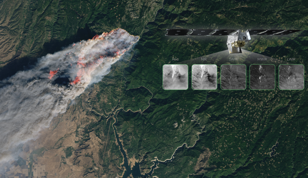
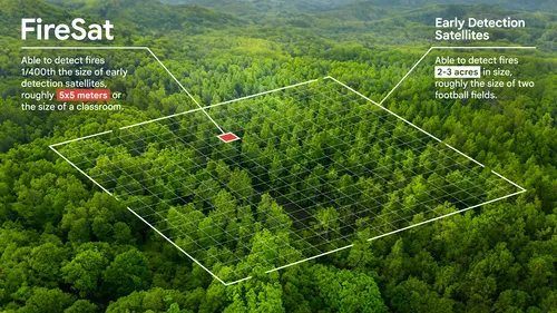
Developed through a collaboration between Google Research, Muon Space, Earth Fire Alliance, Moore Foundation, and global wildfire authorities, FireSat will detect wildfires as small as 5 meters by 5 meters—approximately the size of a classroom—within just 20 minutes.
Currently, wildfire detection largely relies on infrequent, low-resolution satellite imagery, often delayed by hours. FireSat dramatically improves this, offering near real-time data to authorities, significantly enhancing their response capability.
Juliet Rothenberg, reflecting on her past experience during a California wildfire evacuation, described the importance of rapid detection:
“All we received was updated satellite imagery every 12 hours, while throughout the Bay Area, the sky was red and full of smoke. But what was even more shocking was realizing that wildfire authorities didn’t have much better data than we did.”
Funding and Collaboration
The FireSat project is supported financially by Google.org, contributing $13 million through its AI Collaborative: Wildfires initiative, alongside funding from the Moore Foundation. The consortium, including Google Research, Muon Space, and Earth Fire Alliance, launched the satellite from Vandenberg Space Force Base, marking the beginning of a constellation of more than 50 satellites.
RELATED ARTICLE:
Chris Van Arsdale, co-founder and part of the FireSat team, explained the innovation challenge:
“Differentiating between real fires and random ‘noise’ in the environment was a challenge. We had to determine where to draw the line between what is a real fire versus things like sensor issues or misaligned pixels.”
The choice of satellites over other solutions, such as high-altitude drones, was driven significantly by decreasing satellite costs and the ability to consistently monitor remote mountainous regions where wildfires often start.
Economic, Environmental, and Humanitarian Benefits
FireSat’s early detection capabilities offer significant economic and humanitarian advantages by potentially reducing losses from wildfires and enhancing protection for communities and ecosystems globally.
A Tool for Climate Action
Beyond immediate response, FireSat data will create a global historical record of fire behavior, aiding scientists in predicting and modeling future wildfires.
“FireSat is more than just an emergency response tool,” said Juliet Rothenberg. “It’s also an incredible tool for reducing greenhouse gas emissions. It’s actually really beautiful that the constellation contributes to reducing climate change—while also responding to it.”
The ESG News Editorial Team is comprised of veteran financial journalists and sustainability analysts dedicated to providing real-time, objective reporting on global ESG regulations, climate finance, and corporate governance. Our desk monitors daily developments from the SEC, IFRS, CSRD and international regulatory bodies to ensure our 1M+ readers receive accurate, data-driven insights into the evolving sustainable investment landscape. Follow the ESG News Editorial Team for expert reporting on global sustainability standards, ESG disclosures, and climate policy. Access over 10,000 investigative reports and real-time updates.